Your team completed a 3D scanning campaign and handed off the files. Six months later, the digital twin project sits in limbo. Scans live on local servers, operations teams have never accessed them, and the expected operational value has yet to materialize
This is one of the most common patterns in digital twin adoption. The scanning phase feels productive and visible. What comes next is where the real obstacles show up, and most come down to one thing: nobody owns the path from raw geometry to operational use.
Below, we look at where digital twin projects stall after 3D scanning and how to fix each problem before you lose momentum.
Key Takeaways: Digital Twin Project Delays After 3D Scanning
- Digital twin projects stall most often in the handoff between 3D scanning and operational workflows, not during capture itself.
- Raw point cloud data requires conversion, structuring, and governance before it becomes useful for teams beyond scanning specialists.
- Data silos form when scan files remain locked in desktop software that non-specialists cannot access or interpret.
- Streaming scan data in a browser, instead of sharing files, gives non-specialists direct access to it.
- Clear data ownership, defined handoff protocols, and cloud-based access are critical to keeping twin projects on track.
What Happens Between 3D Scanning and a Working Digital Twin?
3D scanning captures the physical environment as a dense collection of measurement points. That raw point cloud is geometry without intelligence. It contains no information about what each surface represents, which systems are installed, or how the space connects to your BIM or asset management workflows.
Moving from scan to operational twin involves several intermediate steps: data registration, cleaning, mesh conversion, alignment with existing models, 2D/3D contextualization, and integration with downstream platforms. Each step requires its own tools, expertise, and quality checks.
When any of these steps lack a clear owner or defined process, the data stalls. Projects that treat scanning as the finish line, rather than the starting point of a longer workflow, are the ones most likely to lose momentum.
Why Does Raw Scan Data Fail to Reach Operations Teams?
Point cloud files are large, complex, and built for specialist software. A large laser scanning campaign can produce terabytes of data. Opening and navigating these files requires dedicated hardware, licensed desktop applications, and technical knowledge most operations teams do not have.
This creates an immediate bottleneck. The scanning team captures the data, but the people who need it for facility management, maintenance planning, or construction coordination cannot access it. The data exists, yet it remains functionally invisible to the stakeholders who would benefit most.
According to a 2026 review published in Research in Engineering Design, cross-company digital twin data exchange still suffers from significant interoperability issues. Engineers frequently resort to manual data identification, conversion, and integration, often resulting in degraded data quality and project delays.
How Do Data Silos Form in Digital Twin Workflows?
Data silos emerge when scan data stays trapped in one department's tools and file systems. The scanning team stores files on local drives that other departments cannot reach. BIM teams create separate copies in their own modeling environments. Operations staff receive static screenshots stripped of measurement capability.
Each copy diverges from the original over time. Without a centralized platform serving as a single source of truth, teams make decisions based on different versions of reality. Coordination meetings become discovery meetings, where participants spend time reconciling conflicting information rather than advancing the project.
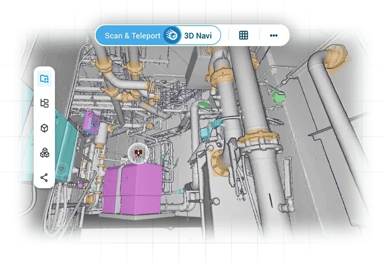
Cintoo tackles this by turning point clouds into high-resolution 3D meshes you can stream in a modern web browser. Every stakeholder, from the scanning specialist to the facility manager, works from the same dataset without downloading heavy files or installing specialized software.
What Role Does Poor Data Governance Play?
Data governance defines who owns the scan data, how it gets updated, and what quality standards apply at each stage. When governance is missing, digital twin projects drift. Files accumulate without version control. Outdated scans get used for critical decisions. Nobody knows which dataset represents current site conditions.
This problem intensifies as projects scale. A single-building scan may be manageable with informal processes. A campus-wide or multi-facility digital twin program generates hundreds of scan datasets across months or years. Without structured governance, the data becomes unmanageable long before it becomes useful.
Effective governance requires naming conventions, defined update cycles, access controls, and clear accountability for data quality. These processes need to be established before scanning begins, not retrofitted after the data has already fragmented across teams.
How Does Misalignment Between Scan and BIM Standards Cause Rework?
Scanning teams and BIM teams often operate under different standards for accuracy, level of detail, and coordinate systems. A scanning team may capture at millimeter precision while the BIM model requires a coarser level of detail. Mismatched coordinate systems mean scans have to be re-aligned or re-georeferenced to the model before anyone can use them together.
This misalignment triggers rework at multiple stages. Models built from misaligned scans contain deviations that surface during clash detection, design coordination, or as-built verification. Each correction requires going back to the source data, which may no longer be easily accessible or may have been modified since the original capture.
With Cintoo’s BIM Edition, teams compare as-built scan data directly against BIM models in a browser and catch deviations before they turn into rework.
Why Do Teams Lose Momentum After the Scanning Phase?
Scanning is a visible, tangible activity. Teams can see equipment deployed on site, track the number of scan positions completed, and measure progress in terabytes captured. This visibility creates a sense of accomplishment that the post-scanning phases rarely match.
After scanning, the work becomes less visible but more critical. Data processing, classification, model alignment, and stakeholder onboarding happen behind screens and across tools. Progress is harder to measure, milestones are less defined, and the people responsible may not be the same team that ran the scanning campaign.
Organizations that maintain momentum typically assign a dedicated digital twin project lead who owns the entire workflow from capture through operational deployment. This role bridges the gap between scanning specialists, BIM managers, IT administrators, and operations teams.
How Does Lack of Cloud Access Stall Collaboration?
When scan data lives on local drives or on-premises servers, collaboration depends on file transfers, USB drives, or email attachments. Large point cloud files can take hours to upload and download. Remote team members and external stakeholders are effectively locked out.
Cloud-based platforms help remove this bottleneck by streaming reality data from the cloud to a standard web browser. Cintoo’s TurboMesh™ technology converts structured scans into multiresolution meshes that are typically 10 to 20 times smaller than the source data, while preserving the scanner’s native resolution.
This shift from file-based to browser-based workflows changes who can participate. Operations managers, facility teams, and remote engineers gain direct access to the same high-resolution data that scanning specialists captured. Decisions can move faster because the people who need the information can open it directly in their browser, without waiting for file transfers.
What Are the Warning Signs That a Digital Twin Project Is Stalling?
Several patterns indicate a digital twin project has lost momentum after scanning. Recognizing them early gives your team the opportunity to intervene before the project loses momentum.
- Scan data has not been accessed in 30+ days. If nobody is processing or analyzing the captured data, the project has effectively paused.
- Operations teams cannot name the scan data location. When stakeholders do not know where the data lives, the handoff has failed.
- BIM models and scans exist in disconnected systems. Parallel datasets without a common viewing environment create conflicting information.
- No defined update cycle exists. A twin reflecting a single moment in time degrades in accuracy daily without planned validation cycles.
- Collaboration happens through screenshots. Flat images cannot replace navigable 3D data for informed decision-making.
How Can Organizations Prevent Digital Twin Stalls After 3D Scanning?
Preventing stalls requires planning the post-scanning workflow before the first scanner is deployed. Define who will receive the data, in what format, on what timeline, and through which platform.
Start with a clear use case. Identify the specific decisions the digital twin needs to support: predictive maintenance scheduling, construction progress monitoring, as-built validation, or facility documentation. Each use case determines the required accuracy, update frequency, and integration needs.
Establish a centralized platform early. Cintoo provides that foundation by giving your entire team browser-based access to reality capture data, BIM models, and collaboration tools in one environment, removing the technical barriers that typically stall adoption between scanning and operations.
In Conclusion: What to do before your next scanning campaign
The gap between 3D scanning and an operational digital twin is where many projects stall. Scanning captures the physical truth. What happens next, how the data moves, who can access it, and how it connects to existing workflows, determines whether that truth becomes operational value or an expensive archive.
Organizations that succeed treat scanning as the first step of a longer, well-governed workflow. They invest in cloud-based access, clear data governance, and cross-team collaboration from day one. Planning these elements early helps protect the value of every scanning campaign.
FAQs About Digital Twin Project Delays After 3D Scanning
Why do digital twin projects stall after 3D scanning is complete?
Projects stall because organizations lack a clear plan for processing, distributing, and integrating scan data after capture. Without defined ownership and accessible platforms, raw point clouds remain unused on local drives while operations teams wait for actionable data.
What is the most common data issue that delays digital twin adoption?
Data silos are the most frequent cause of delay. When scan files remain locked in specialist software, non-technical stakeholders cannot access the information they need. Cintoo helps remove this barrier by converting scan data into 3D meshes that team members can view and use in a web browser.
How does cloud access prevent digital twin project delays?
Cloud-based platforms remove the file-transfer bottleneck that slows collaboration. Cintoo streams high-fidelity 3D meshes to modern web browsers, giving distributed teams access to reality capture data without heavy downloads.
What role does data governance play in digital twin success?
Data governance establishes who owns the scan data, how it gets updated, and what quality standards apply. Without it, datasets fragment, versions multiply, and teams make decisions based on outdated information. A centralized platform with access controls helps keep one current version of the data available to everyone.
How can BIM and VDC teams keep digital twin momentum after scanning?
BIM and VDC teams maintain momentum by defining the post-scan workflow before capture begins. This includes identifying data recipients, setting format and accuracy standards, and establishing a centralized platform where scans, models, and issues converge for ongoing coordination.