Liste des fonctionnalités de Cintoo Cloud
Dernière mise à jour : décembre 2024
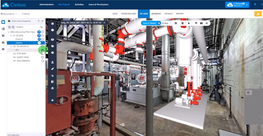
Notre nouvelle interface utilisateur simplifiée.
Découvrez comment la barre d'outils de l'explorateur joue le rôle de plaque tournante pour toutes les ressources et données de votre projet, facilitant ainsi la navigation dans vos données de numérisation 3D.
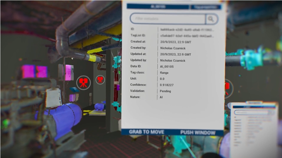
Plongez dans votre projet Cintoo.
Découvrez comment une expérience de métavers industriel peut améliorer les cas d'utilisation qui nécessitent un niveau élevé de collaboration, de simulation et d'interaction, sans compromis sur la précision ou la qualité.
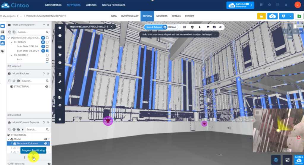
Générer automatiquement des rapports de suivi des progrès.
Améliorer la prise de décision grâce à des données quantitatives utilisées dans les rapports de suivi des progrès. Améliorer la visibilité des parties prenantes en rendant ces informations disponibles dans tous les projets Cintoo.
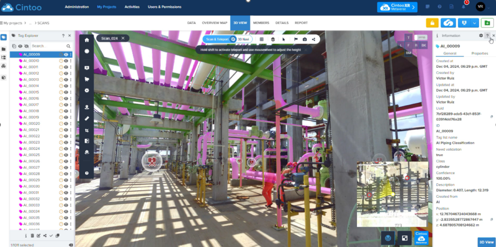
Identifier de nouvelles classes d'actifs grâce à l'IA.
Explorez de nouvelles classifications basées sur la géométrie, notamment les caractéristiques cylindriques et la détection d'objets complexes.
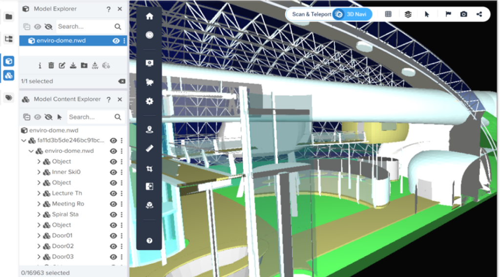
3 nouveaux formats de modèles 3D peuvent être téléchargés dans Cintoo.
Pour les fichiers tels que les modèles IFC, Navisworks, les fichiers NABD et même les fichiers de maillage OBJ, vous pouvez désormais les importer avec la hiérarchie et les métadonnées du modèle.
Regardez le webinaire maintenant !
Découvrez comment vous pouvez transformer les flux de travail de vos projets grâce à de nouvelles fonctionnalités.
Administration
- Tableau de bord, liste des utilisateurs, activités et calendrier
- Ajouter des co-administrateurs et des chefs de projet
- Définir des rôles et des autorisations personnalisés
- Gérer des groupes d'utilisateurs
- Prise en charge de l'authentification unique de l'entreprise (SSO) (frais d'implémentation supplémentaires requis)
- Générer des rapports d'utilisation (date, utilisateurs, entreprises, importation/exportation de scans, de cultures ou de maillages unifiés)
Création de projets
- Choix de l'hébergement automatique dans le nuage avec CDN ou sélection du fournisseur (AWS ou Microsoft Azure) et de la région
- Choix d'un nuage hybride avec vos propres instances AWS ou Azure (frais d'implémentation supplémentaires requis)
- Choix d'un centre de données privé (frais de mise en œuvre supplémentaires requis)
Gestion des projets de numérisation
- Carte, vignettes, liste
- Recherche
- Définir des rôles et des autorisations personnalisés
Collaborer
- Inviter des utilisateurs et des membres de l'équipe à chaque projet (outil de recherche disponible lors de l'invitation d'un nouveau membre)
- Gérer les droits d'accès et de partage
Télécharger des scans terrestres (statiques)
- Télécharger des projets de scans structurés au format RCP, e57, FLS ou LSPROJ
- Prise en charge de l'intensité
- Transformation automatique des nuages de points en maillage 3D pour chaque scan avant le téléchargement
Téléchargement de scans Lidar mobiles intérieurs
- Téléchargement de scans capturés avec des appareils NavVis, GeoSLAM, Gexcel, Emesent, Leica BLK2GO ou Viametris
- Télécharger des scans non structurés dans E57 avec le chemin de la caméra et les images à 360° de la source
- Restructuration des données non structurées avec création de scans 3D "statiques" qui préservent la densité et la précision du nuage de points source.
- Transformation automatique du nuage de points en maillage 3D pour chaque scan avant le téléchargement.
Téléchargement de données de drone
- Téléchargement des données de drone sous forme de nuages de points au format E57
- Génération automatique de points d'observation virtuels (VVP) le long d'une grille horizontale avec une distance personnalisée entre chaque VVP
Téléchargement d'images à 360° (beta)
- Téléchargement d'images sphériques avec leur géolocalisation et leur orientation
- Orientation définie en tant que cap de boussole ou quaternions
Floutage des visages à l'importation
- Flouter automatiquement les visages sur les images panoramiques lors de l'importation de scans statiques ou mobiles, ou de données de drones.
Téléchargement de documents
- Télécharger des documents au format .doc, .pdf, .xls ou .jpg
Affichage
- Compatible avec Google Chrome, Microsoft Edge (V79 ou supérieur) et Mozilla Firefox
- Données, carte d'ensemble en 2D, vue en 3D
- Données : Vignettes ou liste, avec affichage d'images panoramiques haute résolution, informations sur les images numérisées ou à 360° et URL spécifique.
- Vue 3D : Affichage des données de numérisation en mode balayage ou en mode navigation 3D, en images 3D RVB, 3D Intensité, 3D Rayon X, 3D Surface, 3D Hauteur ou 2D Panoramique (mode balayage uniquement) uniquement - Affichage des images 360° pour naviguer entre les numérisations et les images sphériques - Caméra orthographique ou perspective à partir de n'importe lequel des 6 axes - Filtrage des sprites de numérisation (occlusion et/ou portée) en mode balayage.
- Moteur TurboMesh™ en mode Navigation 3D, pour diffuser des données de maillage à la résolution des scans sources.
- Carte de navigation (mini-carte) en vue 3D montrant des icônes de scans et d'images à 360° sur fond RVB, DWG ou carte du site.
- Carte d'ensemble en 2D : Affichage des données de numérisation et des images à 360° en mode orthographique à partir de l'un des 6 axes, en 3D RVB, 3D XRay, 3D Surface ou 3D Height.
- Affichage des modèles BIM en 3D RVB, 3D X-Ray ou 3D Height dans la carte de synthèse et la vue 3D.
Plan du site
- Téléchargement du plan du site (jpeg, PNG)
- Outil d'alignement dans la carte d'ensemble
- Outil d'alignement 3D dans la vue 3D
- Utilisation de la carte du site dans la carte de navigation
Zones de travail
- Créer autant de zones de travail et de sous-zones de travail que nécessaire
- Attribuer des scans ou des modèles BIM/CAD à chaque zone ou sous-zone de travail
- Gérer l'accès des membres de l'équipe aux zones ou sous-zones de travail
- Afficher chaque zone de travail individuellement ou collectivement
Explorateur de ressources
- Parcourez et organisez vos ressources à l'aide de l'explorateur de ressources
- Pour chaque analyse, obtenez les propriétés correspondantes ou utilisez les différentes actions disponibles : modifier, supprimer, ajouter à la zone de travail, partager, télécharger, exporter en CSV, aller à, regarder, masquer, isoler.
Outils de recadrage
- Boîte de recadrage 3D combinée à des curseurs XYZ dans la vue 3D
- Curseurs XYZ dans la carte d'ensemble
- Rotation du recadrage pour l'aligner sur l'écran dans la carte d'ensemble
- Sauvegarde et modification d'un nombre illimité de recadrages
Annotations
- Annoter comme des notes, des notes privées ou des problèmes
- Ajouter des étiquettes, du texte, des photos, des vidéos, des URL, des PDF aux annotations
- Attribuer des notes privées et des problèmes aux membres de l'équipe
- Recherche d'annotations sur la base d'étiquettes
Mesures
- Définir le système d'unités comme métrique, américain ou impérial international avec la précision de la mesure
- Ajouter des mesures linéaires dans la vue 3D (mode balayage ou mode navigation 3D)
- Mesures contraintes (axes X, Y, Z ou disto)
- Mesures de tuyaux (diamètre et coordonnées XYZ du centre)
- Sélectionner un point 3D et coller les coordonnées XYZ
Lecture de la séquence
- Lecture d'une séquence de capture via la ligne de temps
Rapports
- Générer des rapports de mesures et d'annotations en PDF avec des liens hypertextes vers chaque entité
- Créer des captures d'écran
Distribuer et télécharger des scans à partir du nuage
- Télécharger les maillages 3D unifiés aux formats OBJ, FBX et STL (nécessite une étape de création en tant que service Web)
Télécharger les maillages 3D unifiés
- Télécharger les maillages 3D unifiés aux formats OBJ, FBX et STL (nécessite une étape de création en tant que service Web)
Visionneuse 3D partagée
- Partager la visionneuse Cintoo Cloud via une URL ou un email
- Afficher les données de numérisation haute résolution + les modèles BIM/CAD dans Google Chrome ou Mozilla Firefox
- Vue 3D : Affichage des données de numérisation en mode numérisation ou en mode navigation 3D, en images 3D RVB, 3D Intensité, 3D Rayons X, 3D Surface, 3D Hauteur ou 2D Panoramique (mode numérisation uniquement)
- Ajouter un code QR
- Ajouter le logo de l'entreprise
- Définir des limites de temps et des mots de passe
- Partager des métadonnées (mesures, annotations)
- Intégrer les vues partagées dans une iframe à partir de n'importe quel domaine
Visionneuse pour tablettes
- Prise en charge des tablettes Windows, IOS ou Android
- Sélection de projets et de zones de travail
- Mode balayage ou navigation 3D
- Modes d'affichage : 3D RVB, 3D Surface, 2D Panoramique
- Outils : Mesure, Annotation
Localisation
- Toutes les pages du projet Cintoo sont localisées en 7 langues : anglais, français, allemand, italien, espagnol, portugais (brésilien) et japonais.
Cintoo VR Experience App
- Faites l'expérience de vos installations en 3D pour mieux les comprendre.
- Prenez des mesures et identifiez les problèmes
- Comparez les scans aux modèles
Application d'expérience de mise en page 3D
- Améliorez votre expérience de l'Industrial Metaverse pour naviguer dans votre maillage 3D
- Vérifier les dégagements lors du déplacement d'équipements
- Simuler un futur espace de travail
SDK de streaming de Cintoo
- Développez votre propre application
- Disponible sur Unreal ou Unity
Interopérabilité Autodesk Construction Cloud et BIM 360
- Pousser des fichiers RVT, NWD, NWC, 3D DWG, JT ou IFC depuis Autodesk Construction Cloud ou BIM 360 vers Cintoo Cloud.
- Télécharger les modèles BIM avec la hiérarchie, les disciplines et les métadonnées
- Rechercher les mises à jour du modèle dans Autodesk BIM 360 ou Autodesk Construction Cloud
- Sélectionner la transformation à appliquer au modèle Revit (Coordonnées partagées ou Origine à Origine)
- Repousser les questions de Cintoo Cloud vers BIM 360 pour la coordination du projet
Charger des modèles BIM ou CAO à partir d'un disque
- Formats : IFC, DWG, JT, STEP, STP
- Métadonnées non incluses dans le modèle IFC
Explorateur de modèles
- Parcourez votre modèle BIM ou CAO à l'aide de l'explorateur de modèles.
- Pour chaque élément du modèle BIM, utilisez les différentes actions disponibles : cacher, isoler, regarder, aller à
- Lire les métadonnées complètes de chaque modèle et de chaque élément de modèle (uniquement pour les modèles importés depuis ACC et BIM 360)
- Sélectionner un élément de modèle dans la vue 3D
Aligner la numérisation et la BIM
- Aligner le scan sur le BIM/CAD ou le BIM/CAD sur le scan
- Exporter l'alignement vers Revit et Navisworks
Comparer les données de numérisation et le modèle BIM/CAD (numérisation vs. BIM/CAD)
- Superposer le modèle BIM/CAD au scan
- Comparer à l'aide des outils Différence visuelle et Vérification visuelle
- Générer une carte thermique basée sur la tolérance
Comparer les versions de numérisation (Numérisation vs. Numérisation)
- Afficher les versions de numérisation à l'aide de la chronologie
- Aligner un scan sur un autre
- Comparer à l'aide des outils Différence visuelle et Vérification visuelle
- Générer une carte thermique basée sur les tolérances saisies
Suivi des problèmes
- Exportation des problèmes au format BCF (BCF = BIM Collaboration Format)
- Interopérabilité avec BIM Track (pousser ou synchroniser les notes et les problèmes entre Cintoo Cloud et BIM Track)
- Interopérabilité avec Autodesk BIM 360 (pousser les problèmes de Cintoo Cloud vers BIM 360)
- Interopérabilité avec Procore (pousser les problèmes de Cintoo Cloud vers Procore)
Explorateur de balises
- Explorer les listes de balises et les balises dans l'onglet DONNEES ou dans l'Explorateur de balises de la vue 3D
Liste de balises
- Créer des listes de balises et des balises
- Pour chaque balise, ajoutez jusqu'à 20 métadonnées (les métadonnées peuvent être des liens hypertextes vers votre jumeau numérique ou votre plateforme de documentation).
Balisage manuel
- Créer une balise autour d'un équipement à l'aide de l'outil "bounding box".
- Modifier manuellement le tag avec toutes les métadonnées nécessaires
Importation de listes de balises
- Importer des listes de balises dans un fichier CSV qui contient l'ID de l'équipement, l'emplacement, les métadonnées et l'hyperlien.
- Modifier les listes de balises (ajouter des listes existantes, ajouter manuellement de nouvelles balises, modifier chaque balise pour ajuster le cadre de délimitation par exemple)
- Supprimer des listes de balises
Recherche automatique de tags dans vos scans grâce au moteur d'intelligence artificielle de Cintoo
- Recherche automatique de différents tags pour les géolocaliser et les classer dans vos scans
- Classes de tags disponibles : boîtiers de contrôle, boîtiers électriques, moteurs électriques, brides, manomètres, valves
Affichage des tags dans la vue 3D
- Afficher les balises avec leur(s) meilleure(s) vue(s) de numérisation dans la vue 3D
- Modifier la vue de numérisation ou la vue 3D pour chaque balise
- Cliquer sur la balise dans la liste ou dans la vue 3D pour accéder aux informations sur le bien
- Afficher les métadonnées de la balise à l'aide de l'Explorateur de balises
Recherche de balises
- Rechercher des balises dans la liste avec plusieurs éléments
Recherche de vues
- Partager des vues d'étiquettes sous forme d'hyperliens ou de codes QR
Exporter des listes d'étiquettes
- Exporter les listes d'étiquettes dans un fichier CSV ou Excel avec la vue de numérisation pour chaque étiquette.
Afficher les résultats des données d'inspection sur les images 360
- Données d'inspection calculées par une tierce partie (analyse de la rouille ou de la corrosion par exemple) sur des images 360 sources exportées de Cintoo
- Les données d'inspection sont ensuite affichées dans Cintoo via un shader d'image 360 spécifique.
Création de maillages 3D unifiés (BETA)
- Création de maillages 3D unifiés avec photo-texture à partir de cultures
- Jusqu'à 100 scans
- Sélection de la densité à partir de 0,2 cm / 0,1 pouce
- Sélection du format (OBJ, FBX, STL)
Les API de Cintoo Cloud permettent d'appeler la plupart des ressources de Cintoo Cloud. Les appels API actuels sont les suivants :
- Lister ou obtenir vos projets Cintoo Cloud
- Déplacer un projet vers un autre abonnement
- Lister les fichiers, y compris les scans, les modèles, les géo-images
- Lister, créer, mettre à jour ou supprimer des balises ou des listes de balises
- Lister ou obtenir des groupes d'utilisateurs
- Lister ou obtenir des rôles
- Lister les abonnements
- Lister ou obtenir des utilisateurs
