In an era captivated by mobile and rapid mapping technologies like SLAM, a quiet renaissance is happening: the resurgence of fixed LiDAR as the gold standard for high-fidelity geospatial data. While SLAM offers speed and flexibility, the growing demands of AI-driven asset detection are exposing its limitations in precision, consistency, and repeatability. This white paper explores how fixed LiDAR systems, long viewed as legacy or niche, are regaining prominence as AI models mature and require denser, more reliable input. As infrastructure, energy, and urban environments turn to automation for monitoring and planning, the accuracy and permanence of fixed LiDAR installations are proving indispensable. Cintoo, with its cloud-native platform and robust handling of high-resolution reality capture data, is uniquely positioned to capitalize on this shift. By bridging the gap between fixed LiDAR systems and scalable AI workflows, Cintoo is helping reshape the geospatial intelligence landscape one accurate point cloud at a time.
Fixed (terrestrial) LiDAR scanners deliver extremely high-density, high-accuracy point clouds by capturing scenes from stable tripod positions. These structured scans produce precise spatial grids of data that capture sub-centimeter detail of every surface. In contrast, SLAM based mobile scanners trade some accuracy and range for speed; their real-time mapping introduces drift and noise, so SLAM laser scanning might not achieve the same level of accuracy as tripod-based systems.
LiDAR methods are seen as expensive and inflexible, which is why they’ve fallen from favor. On the other hand, SLAM is a preferred method as it scales quickly and remains flexible. However, the AI shift is driving a new conversion point. Since it’s moving away from pure visualization of the data and more towards the interpretation of data, more accuracy is required over time.
.png?width=549&height=396&name=Group%2015937%20(2).png)
SLAM’s strengths again are: mobility, autonomy, indoor/outdoor transitions. But AI needs more than approximate maps. To allow AI to operate at a better efficiency, it needs accuracy, repeatability, and confidence. The noise, drift, and inconsistency in SLAM data across time doesn’t allow it to scale consistently.
Because of fixed LiDAR’s ability to produce highly stable, high-density point clouds, it becomes ideal to use for training and inference in AI models. LiDAR’s ability to hold consistent frames of reference without the drift enables pixel-accurate asset detection such as utility poles, surface degradation, and micro-topography.
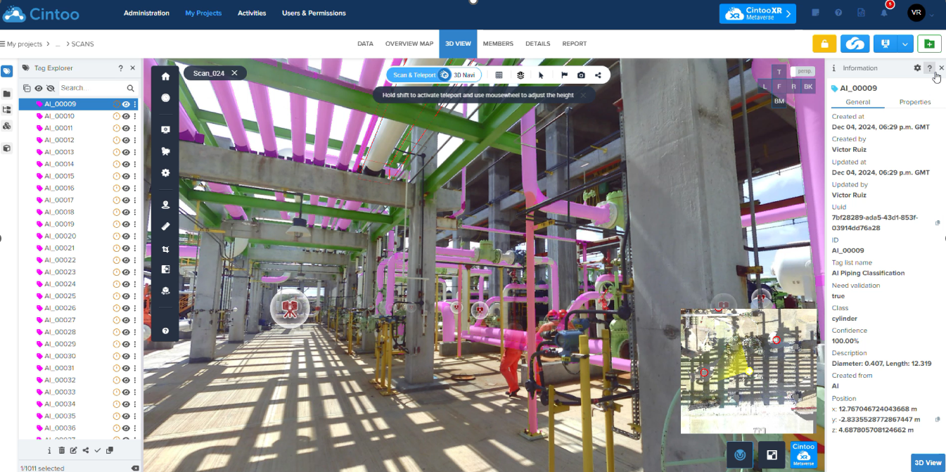
By pairing fixed LiDAR’s raw precision with Cintoo’s AI engine, every object in the scene can be automatically detected and classified. Cintoo’s deep-learning tag-detection tools analyze the dense point cloud and automatically geolocate and classify tags in the 3D scans, identifying Industry 4.0 assets like valves, flanges, motors, and control panels. The result is a precision synergy: the unrivaled fidelity of static LiDAR feeds the AI with clean, stable data, enabling faster, more reliable asset tagging than manual inspection. This precision-first approach gives decision-makers confidence that their digital twin reflects the real world with millimeter accuracy, while AI-driven workflows eliminate repetitive manual tasks. These results are repeated for longer and more details components of a site, like a tunnel.

In a major infrastructure project in the UK the fixed LiDAR + Cintoo approach delivered dramatic results. Survey teams captured the full 1.1-mile tunnel with high-resolution terrestrial scanners, then uploaded the massive dataset to Cintoo. There, engineers overlaid CAD drawings and ran Cintoo’s AI tag engine to identify structural elements (shafts). Stakeholders could remotely navigate the tunnel model from any browser, pan to areas of concern, and annotate issues without returning to site.
The ROI was clear: by shifting inspections into the cloud, field travel and downtime were slashed. Inspectors reviewed as-built tunnel conditions virtually, detecting a misaligned tunnel liner and safety-clearance issues weeks earlier than traditional methods. This early insight avoided costly rework during renovation. Meanwhile, contractors gained a single source of truth for planning, the scan-driven digital twin, which accelerated schedule coordination and reduced on-site surveying by days.
This project and more demonstrates precision in LiDAR surveys, empowered by Cintoo’s mesh visualization and AI analytics.
Fixed LiDAR’s cost and permanence used to be barriers. Now, edge computing, real time processing, and AI integration are changing that.
Modern scanners are faster and cheaper, and cloud platforms like Cintoo eliminate data friction. Cintoo’s patented mesh compression and streaming technology mean that even multi-gigapoint clouds can be viewed instantly on a laptop, without massive IT investments. In practice, this means engineers and owners can afford more detail for the same budget: architects and operators now plan with as‐built accuracy rather than schematic guesses. Every extra point of resolution pays back by reducing uncertainty. For example, a dense LiDAR survey integrated into the BIM model can spot millimeter misalignments that would otherwise trigger late-stage change orders.
In short, the economics of detail now favor maximum fidelity. The up-front investment in high-resolution scanning yields downstream savings in engineering, construction, and operations.
Fixed installations now become “living infrastructure” with always-on sensing. Integration into digital twins, predictive maintenance, and environmental monitoring means that the data can be used over a longer duration of time and with more accuracy. Ultimately, these data pipelines are optimized for AI ingestion, not just human viewing, meaning you and your team can start gaining momentum with AI precision-based methods for better project delivery.

Cintoo was founded on the principle that high fidelity 3D data shouldn’t be trapped in local environments or heavyweight file systems. Its core platform enables cloud-based visualization, collaboration, and management of reality capture data-making it ideal for handling dense, fixed LiDAR scans.
As fixed LiDAR becomes integral to digital twin environments, Cintoo provides the connective tissue. Its tools allow for seamless integration into BIM and GIS workflows.
AI thrives on clean, structured, and repeatable input. Cintoo’s ability to host, align, and compare LiDAR scans over time creates the consistency AI detection models need to perform at scale.
Cintoo’s cloud-native architecture supports enterprise-level collaboration across stakeholders.
Higher confidence in inspections and digital twins with fixed sensors and Cintoo’s scalable access.
Centralized, cloud-native tools for collaboration and analytics.
AI Developers: Use Cintoo-hosted scans as consistent, high-quality training and inference datasets.
Regulators & Planners: A new standard of accuracy and auditability powered by fixed LiDAR + Cintoo.
While SLAM technologies excelled in speed and mobility, fixed LiDAR is proving to be the cornerstone of next-generation geospatial intelligence. As digital twins, AI models, and automated systems take center stage in infrastructure and asset management, the demand is no longer for approximate data—it’s for verified, repeatable precision. Fixed LiDAR, especially when paired with platforms like Cintoo that transform static scans into collaborative, AI-ready environments, is emerging not just as an alternative, but as the foundation for intelligent, data-driven decision-making.

Next: Watch AI-Driven Click & Tag and Transform Asset Tagging From Minutes to Seconds