Water utilities are being asked to do more with less, from extending asset life, meeting tighter regulations, managing urban demand and reducing operating expenditure.
And this is all while working with ageing, poorly documented infrastructure. Operators are continually hindered by fragmented GIS, engineering drawings, maintenance logs and legacy documentation, which slow decision-making and increase risk.
This is why reality capture is an operational necessity.
A persistent challenge in water infrastructure is the lack of a single source of meaningful data. 3D scans, P&IDs, BIM models and asset records all reside in separate systems, leading to more time spent collecting the data than drawing on insights from it.
By transforming massive point cloud data into a unified, visual environment, utilities can align scan data with engineering documentation and asset information in one navigable context.
As a result, teams gain faster access to trusted information, avoid interpretation errors and can collaborate on a shared understanding of what’s happening across their sites.
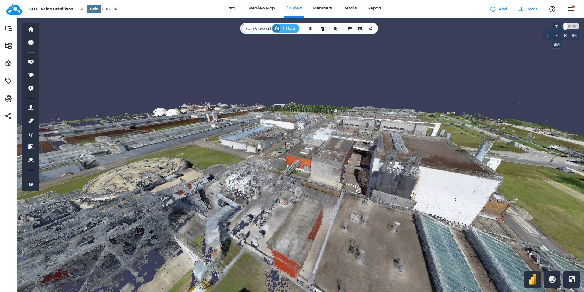
SIAAP discovered a way to transform its massive point cloud files from its 3D scanning into a unified data model that merged GIS, P&IDs, engineering drawings, and asset data. This integration has saved countless hours that would have been spent searching across incompatible systems.  Scan data is streamed in high-resolution 3D mesh in a web-based browser.
 The mesh view allows clearer context and visualization.
Laser scanning can provide operations and maintenance teams with the level of clarity and detail needed for design work, inspections, and asset management. Here are just some of the ways where reality capture can fit and thus scale operations:
Inspection and documentation of sewer tunnel networks using laser scanners provides high precision reviews of the current As-Built conditions, and damage to the networks can be detected and remediated at an early stage.
Laser scanning of sewage treatment plants can be used to plan extensions, refurbishments, equipment replacement and upgrades. Renovation and modernization projects can be planned and executed in a more cost and time efficient way using the 3D scan data.
Dams, pump stations, flood protection systems or other hydraulic structures can be scanned to map the building's geometry. Pipes and tubes can also be scanned to ensure future maintenance is based off a scanner with 1-5 millimeter precision to ensure the accuracy of measurements and calculations are within the project’s specified tolerance rules, and are ‘surveyor grade’.
Here a few quick snapshots of some of the ROI use cases that scan data, captured by a variety of laser scanners, can provide:
Complex systems and subterrain water networks can be captured in high precision using the scanner without the need to physically access these networks through digging, which is high in cost and leads to service outages and shutdowns while the work takes place.
The output are 3D scans and models providing a comprehensive analysis, planning, and a high precision dataset for ongoing renovation and maintenance measures.
Using the scan data, significant cost and time savings can be made, as unforeseen problems are identified at an early stage.
Inspection timelines are markedly reduced, resulting in fewer operational failures and availability of plant equipment and machinery.
Optimized maintenance planning minimizes long-term risks and increases operational safety. In addition, contactless measurement ensures greater occupational safety, especially in areas that are difficult to access or dangerous.
Operators, planners, and construction companies thus obtain an up-to-date picture of reality that reduces risks, avoids planning errors, and significantly improves collaboration across all project phases and for multiple stakeholders working on the project.
Locating and verifying assets in large, complex treatment facilities has historically meant repeated site visits for inspections and measuring up, taking up valuable time and exposing teams to potential hazards.
Instead, accessing scan data in a virtual 3D environment allows teams to identify equipment, take measurements and plan interventions, all before arriving on site.
Consequently, companies benefit from a measurable reduction in site visits and improved workforce safety, with specialist resources allocated more efficiently.
Outdated plans are a leading cause of rework in infrastructure upgrades. Scan data provides a reliable reference that allows engineers to validate designs against actual site conditions before work begins. Even small clashes or overlooked structural elements, if caught early in the process, can prevent delays, downtime and cost overruns.
“The ability to show the existing context to all stakeholders during review and concept meetings enhances positive exchanges and common understanding between stakeholders, ultimately leading to smoother-run projects,” Klervie Civel-Rivoal, BIM Manager at SIAAP, says.
When scan data is integrated into organizations’ workflows, it becomes a persistent operational asset that:
Operations teams can use for remote inspection and planning
Maintenance teams can reference for asset location and context
Project teams can explore for progress validation and deviation detection
New team members can visit to familiarize themselves with facilities before going on site
 Locate assets in full 3D context.
In an environment where capital remains constrained and scrutiny is intensifying, reality capture is one of the most practical ways water companies can reduce risk, improve safety, control costs and modernize infrastructure without major disruption to daily operations.
SIAAP has imported over 6,000 pieces of equipment and 120,000 documents into their centralized 3D data platform, achieving major efficiencies in asset tracking, planning, and collaboration.
The benefits are vast and it begs the question: why would water companies operate without this layer of visibility and foresight?
Watch Cintoo's latest webinar on asset tagging and P&ID use cases.
Ready to dive into the platform? Try a free demo today!