Unlike traditional point clouds that remain in their segmented, individual scan states, a unified point clouds need to be restructured in a typical workflow to provide the full range of information from the scan data. Typically, unified point clouds lack the structure so it's impossible to leverage all information from the project.
Cintoo now offers more ways to use structured point clouds by restructuring the unified point cloud at the resolution of the source file. By compressing it using Cintoo’s point-cloud-to-meshcapabilities, the structure is maintained, and the data becomes actionable. Learn more about unified point clouds here, or to start importing in Cintoo today, visit our Knowledge Base.
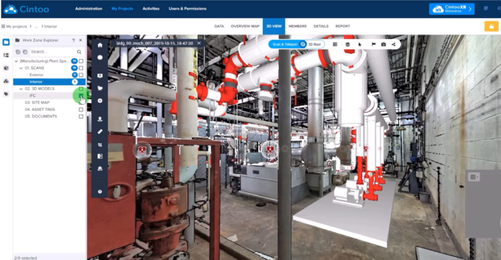
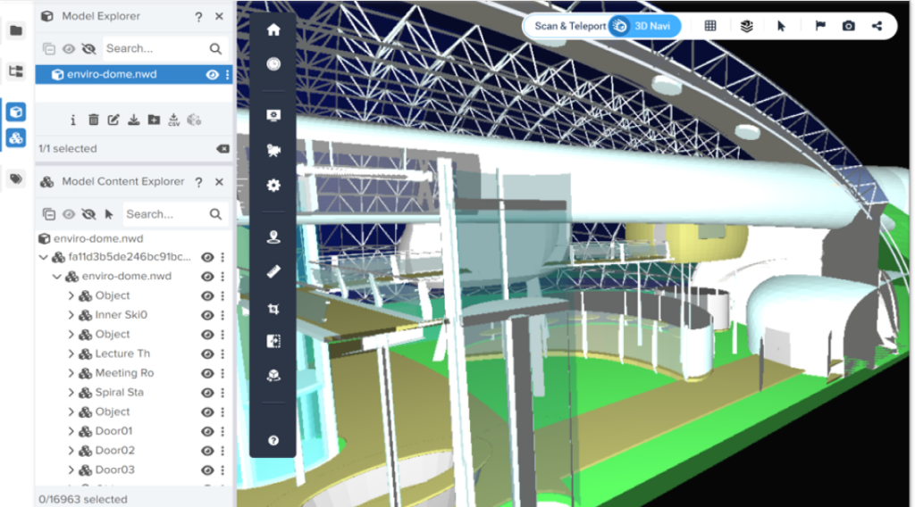
Our new user interface made simple.
A New User Interface to Explore Your Project Assets
Learn how the explorer toolbar acts as the central hub for all your project assets and data, making it simple and easy to navigate your 3D scan data.
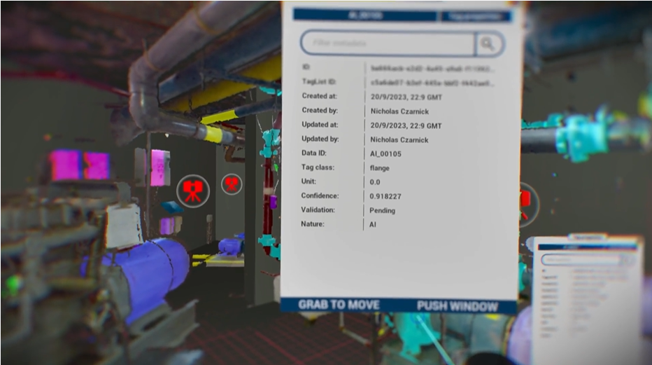
Immerse yourself in your Cintoo project.
The Cintoo Metaverse
Discover how an industrial metaverse experience can enhance use cases that require a high level of collaboration, simulation, and interaction, with no compromise to accuracy or quality.
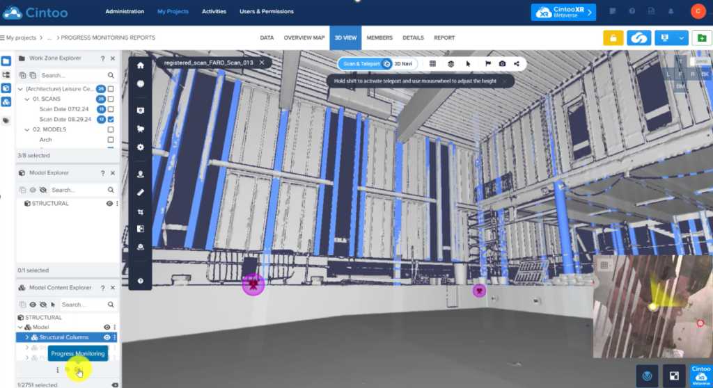
Improve decision making with quantitative data used in progress monitoring reports. Enhance stakeholder visibility making this information available in all Cintoo projects.
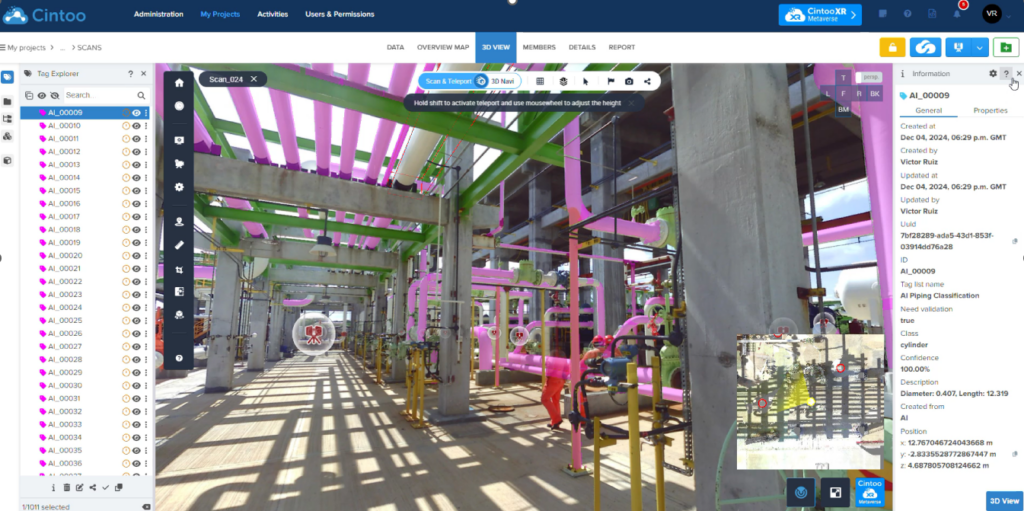
Identify new asset classes with AI.
AI Classification Toolkit
Explore new classifications driven by geometry, including cylindrical features and complex object detection.
3 new 3D model formats can be uploaded into Cintoo.
New Model Formats Available from Local Disk
For files like IFC models, Navisworks, NABD files, even OBJ mesh files, you can now import those with model hierarchy and model metadata.
Watch the webinar now!
Watch: The Future of 3D Scan Data
Learn how you can transform your project workflows with new features.
Support of corporate Single Sign-On (SSO) (additional implementation fee required)
Generate Usage Reports (date, users, companies, import/export of scans, crops or unified meshes)
Create Projects
Choice of Automatic Cloud Hosting with CDN or selection of provider (AWS or Microsoft Azure) and region
Choice of hybrid cloud with your own AWS or Azure instances (additional implementation fee required)
Choice of private data center (additional implementation fee required)
Manage Scan Projects
Map, Thumbnails, List
Search
Define custom roles and permissions
Collaborate
Invite Users & Team members to each project (search tool available when inviting a new member)
Manage access & sharing rights
Upload Terrestrial (Static) Scans
Upload structured scan projects in RCP, e57, FLS or LSPROJ format
Support of intensity
Automatic point cloud-to-3D mesh transformation for each scan prior to the upload
Upload Indoor Mobile Lidar Scans
Upload scans captured with NavVis, GeoSLAM , Gexcel, Emesent, Leica BLK2GO or Viametris devices
Upload unstructured scans in E57 together with camera path and source 360° images
Restructuring or unstructured data with creation of ‘static’ 3D scans that preserve the source point cloud density and accuracy
Automatic point cloud-to-3D mesh transformation for each scan prior to the upload
Upload Drone Data
Upload drone data as point cloud in E57 format
Automatically generate Virtual Vantage Points (VVPs) along an horizontal grid with a custom distance between each VVP
Upload 360° images (beta)
Upload spherical images with their geolocation and orientation
Orientation set as compass heading or quaternions
Face Blurring at Import
Automatically blur faces on panoramic images when uploading static or mobile scans, or drone data
Upload Documents
Upload documents in .doc, .pdf, .xls or .jpg format
View
Supports Google Chrome, Microsoft Edge (V79 or higher) and Mozilla Firefox
Data, 2D Overview Map, 3D View
Data: Thumbnails or list, with high-res panoramic picture display, scan or 360° images information and specific URL
3D View: Display scan data in Scan Mode or 3D Navigation Mode, in 3D RGB, 3D Intensity, 3D X-Ray, 3D Surface, 3D Height or 2D Panoramic Images (Scan Mode only) only – Display 360° images to navigate between scans and spherical images – Orthographic or perspective camera from any of the 6 axes – Scan sprites filtering (occlusion and/or range) in Scan Mode
TurboMesh™ engine in 3D Navigation mode, to stream mesh data at the resolution of the source scans
Navigation Map (mini-map) in 3D View showing scan and 360° images icons over RGB, DWG or Site Map background
2D Overview Map: Display scan data and 360° images in orthographic mode from any of the 6 axes, in 3D RGB, 3D XRay, 3D Surface or 3D Height
Display BIM models in 3D RGB, 3D X-Ray, or 3D Height in Overview Map and 3D View
Site Map
Site Map upload (jpeg, PNG)
Alignment tool in Overview Map
3D Alignment tool in 3D View
Use of Site Map in Navigation Map
Work Zones
Create as many Work Zones and sub-Work Zones as necessary
Assign scans or BIM/CAD models to each Work Zone or sub-Work Zone
Manage team member access to Work Zones or sub-Work Zones
Display each Work Zone individually or collectively
Resource Explorer
Browse and organize your resources using the Resource Explorer
For each scan, get the corresponding properties or use several available actions: edit, delete, add to Work Zone, share, download, export in CSV, go to, look at, hide, isolate
Cropping Tools
3D crop box combined with XYZ sliders in 3D View
XYZ sliders in Overview Map
Rotate crop to align with screen in Overview Map
Save & edit unlimited crops
Annotations
Annotate as notes, private notes or issues
Add labels, text, photo, video, URL, PDF to the annotations
Assign private notes and issues to team members
Search for annotations based on labels
Measurements
Set unit system as metric, US or international Imperial with precision of measurement
Add linear measurements in 3D View (Scan Mode or 3D Navigation Mode)
Constrained measurements (X, Y, Z axis or disto)
Pipe measurements (diameter and center XYZ coordinates)
Pick 3D point and paste XYZ coordinates
Play Sequence
Play capture sequence via the timeline
Reports
Generate Measurement & Annotation reports in PDF with hyperlinks to each entity
Create screenshots
Distribute and Download Scans from the Cloud
Download the Unified 3D Meshes in OBJ, FBX and STL format (requires a creation step as a Web Service)
Download Unified 3D Meshes
Download the Unified 3D Meshes in OBJ, FBX and STL format (requires a creation step as a Web Service)
Shared 3D Viewer
Share Cintoo Cloud viewer via URL or email
Display high-resolution Scan data + BIM/CAD models in Google Chrome or Mozilla Firefox
3D View: Display scan data in Scan Mode or 3D Navigation Mode, in 3D RGB, 3D Intensity, 3D X-Ray, 3D Surface, 3D Height or 2D Panoramic Images (Scan Mode only)
Add QR code
Add company logo
Set time limits and passwords
Share metadata (measurements, annotations)
Embed Shared Views in iframe from any domain
Tablet Viewer
Support of Windows, IOS or Android tablets
Project and Work Zone Selectiom
Scan mode or 3D Navigation
Display modes: 3D RGB, 3D Surface, 2D Panoramic Image
Tools: Measure, Annotate
Localization
All Cintoo Project pages localized in 7 languages: English, French, German, Italian, Spanish, Portuguese (Brazilian) and Japanese