In the rapidly evolving construction industry, technology continues to reshape how projects are planned, executed, and maintained. Among these innovations, LiDAR (Light Detection and Ranging) technology stands out for its exceptional accuracy and efficiency in capturing spatial data. But it's the addition of color to LiDAR point clouds that truly revolutionizes how construction professionals visualize and interact with digital environments. LiDAR point cloud color not only enhances the realism of 3D models but also provides valuable contextual information, making it an indispensable tool in modern construction workflows.
How LiDAR Point Clouds Are Captured
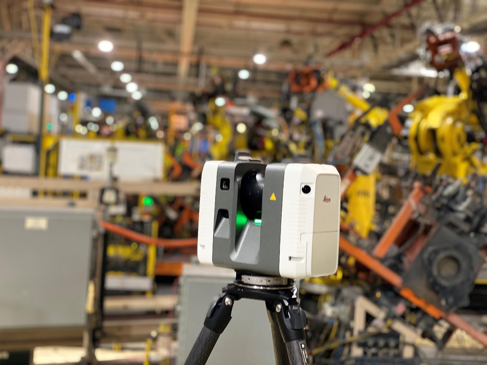
LiDAR point clouds are created by emitting laser pulses from a sensor that measures the time it takes for the light to return after hitting an object. This process generates millions of data points, each representing a precise 3D coordinate in space. When combined, these points form a dense and accurate digital representation of the scanned environment. Traditionally, LiDAR point clouds were monochromatic, displaying objects as clusters of points without any color. However, recent advancements have made it possible to capture colorized point clouds by integrating high-resolution cameras with LiDAR sensors.
By synchronizing photographic data with each laser pulse, these systems assign RGB values to each point, effectively painting the digital model. This technique enhances the realism of the point cloud, making it easier to interpret and analyze. In construction, this means more detailed site inspections, accurate material identification, and improved communication among stakeholders.
It also means a true visualization of the site exists within an accessible model. Clarity of the representation allows construction workers, architects and engineers to go into their project sites and gain a clear understanding of site conditions and discrepancies.
Why LiDAR Point Cloud Color Is Essential in Construction
LiDAR point cloud color is more than just a visual enhancement; it’s a powerful tool that adds context and clarity to 3D data. In the construction industry, colorized point clouds help professionals distinguish between different materials, identify structural elements, and understand environmental conditions with greater precision. This detailed visualization aids in accurate site assessments, reducing the risk of errors that can lead to costly rework.
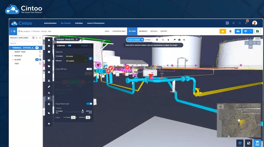
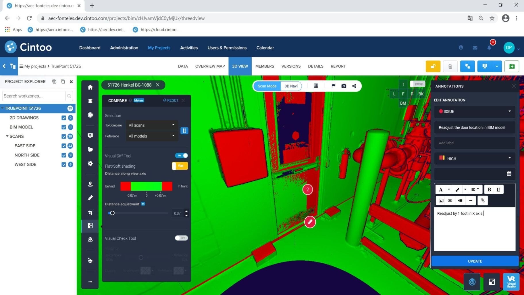
Colorized point clouds also enhance the ability to compare as-built conditions with design models. By overlaying colored LiDAR point clouds onto Building Information Models (BIM), construction teams can easily identify discrepancies, ensuring projects stay on track and within budget. The combination of high accuracy and realistic visualization makes LiDAR point cloud color an invaluable asset for architects, engineers, and contractors.
The Benefits of Color in LiDAR Point Clouds
One of the most significant advantages of LiDAR point cloud color is improved data interpretation. In monochrome point clouds, differentiating between objects of similar shape and size can be challenging. However, with colorized data, users can easily distinguish between vegetation, pavement, structures, and other site features. This is especially useful in complex construction sites where multiple elements are closely intertwined.
Color also enhances the accuracy of digital twin models, providing a more immersive experience for virtual site visits and remote inspections. Stakeholders can explore detailed 3D representations without needing to visit the physical site, saving time and reducing safety risks. Moreover, colorized point clouds improve communication and collaboration by providing a common visual language for all team members, from designers to construction managers.
Other Key Benefits of LiDAR Point Clouds
Beyond color, LiDAR point clouds offer several other advantages in construction. They provide unmatched accuracy and high-resolution data, capturing even the smallest details of a site. This precision is crucial for tasks such as volumetric calculations, topographic mapping, and structural analysis. Additionally, LiDAR technology is capable of rapid data collection, significantly reducing the time required for site surveys compared to traditional methods.
LiDAR is also effective in capturing data in challenging environments, such as dense vegetation, complex urban landscapes, or hazardous construction sites. Its ability to penetrate foliage and record ground elevation makes it an ideal tool for earthwork planning, environmental impact assessments, and infrastructure development. Furthermore, LiDAR point clouds are compatible with various software platforms, enabling seamless integration with BIM and CAD systems.
Use Cases of LiDAR Point Cloud Color in Construction
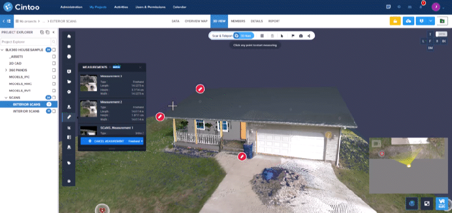
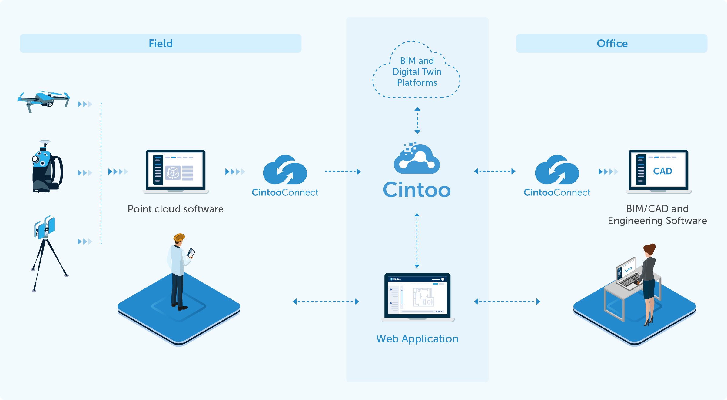
LiDAR point cloud color is transforming how construction projects are managed, from initial design to final inspection. One notable application is in site planning and analysis. By generating detailed and realistic 3D models, construction teams can perform accurate site assessments, identify potential challenges, and optimize project layouts. This level of detail improves decision-making and reduces the risk of design conflicts. But LiDAR point clouds perform and function best when streamed in a web-based browser, allowing easy accessibility and defined clarity.

Cintoo allows for LiDAR point clouds to be uploaded into the web-based resolution, compressing point clouds to 10-20 times smaller, allowing for easier streaming and navigational abilities. LiDAR point clouds maintain their depth and breadth, ensuring no details are lost. RGB colour mode is maintained, and even allows for the possibility to convert to 3D conversions and mesh-based views. In Cintoo, there’s many more possibilities to view your project data. This means that project managers can monitor construction milestones and ensure compliance with design specifications since the LiDAR point cloud is maintained in high-definition detail. This proactive approach minimizes delays and enhances quality control.
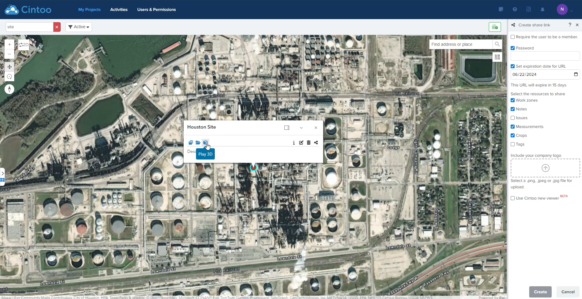
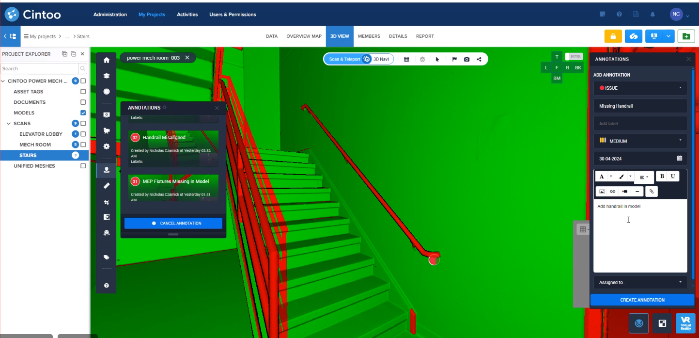
LiDAR point cloud color is also invaluable for facility management and maintenance. As-built documentation created from colorized point clouds provides a comprehensive digital record of the project, which is essential for future renovations, maintenance, or expansions. These digital records become actionable and shareable in Cintoo, so every stakeholder is communicating over the same visual aid and language–ultimately allowing for a single source of visual truth. By working from a single source of visual truth, costly mistakes are reworks can be avoided since miscommunication and misunderstanding greatly declines.
In addition, facility managers can quickly access accurate 3D representations of the building’s structure and systems, streamlining maintenance workflows and reducing operational costs. Part of this comes from the ability for construction managers and architects to upload BIM/CAD files into the Cintoo platform and overlay a working design model against as-built conditions. This ensures the next level of accuracy in maintaining efficient and correct designs so that, upon the time of implementation, no clashes crop up.
The Future of LiDAR Point Cloud Color in Construction
As construction projects become increasingly complex, the demand for precise and contextualized data continues to grow. LiDAR point cloud color addresses this need by providing high-fidelity digital twins that enhance project visualization, accuracy, and collaboration. With ongoing advancements in sensor technology and data processing, the future of LiDAR in construction looks promising. We can expect more seamless integration with augmented reality (AR) and virtual reality (VR) platforms, enabling immersive experiences for design reviews, safety training, and client presentations.
Furthermore, as artificial intelligence (AI) and machine learning algorithms evolve, the analysis of colorized point clouds will become more automated and insightful. AI-powered tools will be able to detect defects, classify materials, and even predict maintenance needs based on historical data trends. This level of automation will significantly improve efficiency and productivity in construction projects. For instance, Cintoo’s progress monitoring addresses chief concerns in communicating project milestones and timelines. Cintoo’s built-in progress monitoring allows its users to compare progress against the current state of a project, uploading documentation records for complete and instantaneous notation.
LiDAR point cloud color is revolutionizing the construction industry by providing detailed, accurate, and contextualized 3D data. Its ability to capture and visualize realistic digital models enhances site assessments, design validation, progress tracking, and facility management. By leveraging the power of colorized point clouds, and especially when uploading them into a web-based browser, construction professionals can make more informed decisions, reduce errors, and improve overall project efficiency.
As technology continues to advance, the use of LiDAR point cloud color in construction will only grow, paving the way for smarter, safer, and more efficient building practices.